Showing posts with label google. Show all posts

Monday, September 17, 2018

History of The Shawnee: Part 3

PART 3:
As published in the Official Newsletter of the Piqua Shawnee (Fall 2018)
By Barbara Lehmann, Piqua Shawnee Tribal Historic Preservation Officer
 
Barbara’s History Corner:
 
Bezallion informed the governor that the Shaonois of Carolina he was told had killed several Christians; whereupon the government of that province raised the said flat headed Indians, and joined some Christians to them, besieged and have taken, as it is thought, the said Shaonois town.” Those who escaped probably fled to the north and joined their kindred in Pennsylvania. In 1708 Gov. Johnson, of South Carolina, reported the “Savannahs” on Savannah River as occupying 3 villages and numbering about 150 men 6. In 1715 the “Savanos” still in Carolina were reported to live 150 miles northwest of Charleston, and still to occupy 3 villages, but with only 233 inhabitants in all.

A part of those who had come from the south in 1694 had joined the Mahican and become a part of that tribe. Those who had settled on the Delaware, after remaining there some years, removed to the Wyoming valley on the Susquehanna and established themselves in a village on the west bank near the present Wyoming, Pennsylvania. It is probable that they were joined here by that part of the tribe which had settled at Pequea, which was abandoned about 1730. When the Delawares and Munsee were forced to leave the Delaware River in 1742 they also moved over to the Wyoming valley, then in possession of the Shawnee, and built a village on the east bank of the river opposite that occupied by the latter tribe. In 1740 the Quakers began work among the Shawnee at Wyoming and were followed two years later by the Moravian Zinzendorf. As a result of this missionary labor the Shawnee on the Susquehanna remained neutral for some time during the French and Indian war, which began in 1754, while their brethren on the Ohio were active allies of the French. About the year 1755 or 1756, in consequence of a quarrel with the Delawares, said to have been caused by a childish dispute over a grasshopper, the Shawnee abandoned the Susquehanna and joined the rest of their tribe on the upper waters of the Ohio, where they soon became allies of the French. Some of the eastern Shawnee had already joined those on the Ohio, probably in small parties and at different times, for in the report of the Albany congress of 1754 it is found that some of that tribe had removed from Pennsylvania to the Ohio about 30 years previously, and in 1735 a Shawnee band known as Shaweygria (Hathawekela), consisting of about 40 families, described as living with the other Shawnee on Allegheny river, refused to return to the Susquehanna at the solicitation of the Delawares and Iroquois. The only clue in regard to the number of these eastern Shawnee is Drake’s statement that in 1732 there were 700 Indian warriors in Pennsylvania, of whom half were Shawnee from the south. This would give them a total population of about 1,200, which is probably too high, unless those on the Ohio are included in the estimate.

Having shown the identity of the Savannah with the Shawnee, and followed their wanderings from Savannah river to the Ohio during a period of about 80 years, it remains to trace the history of the other, and apparently more numerous, division upon the Cumberland, who preceded the Carolina band in the region of the upper Ohio river, and seem never to have crossed the Alleghanies to the eastward.
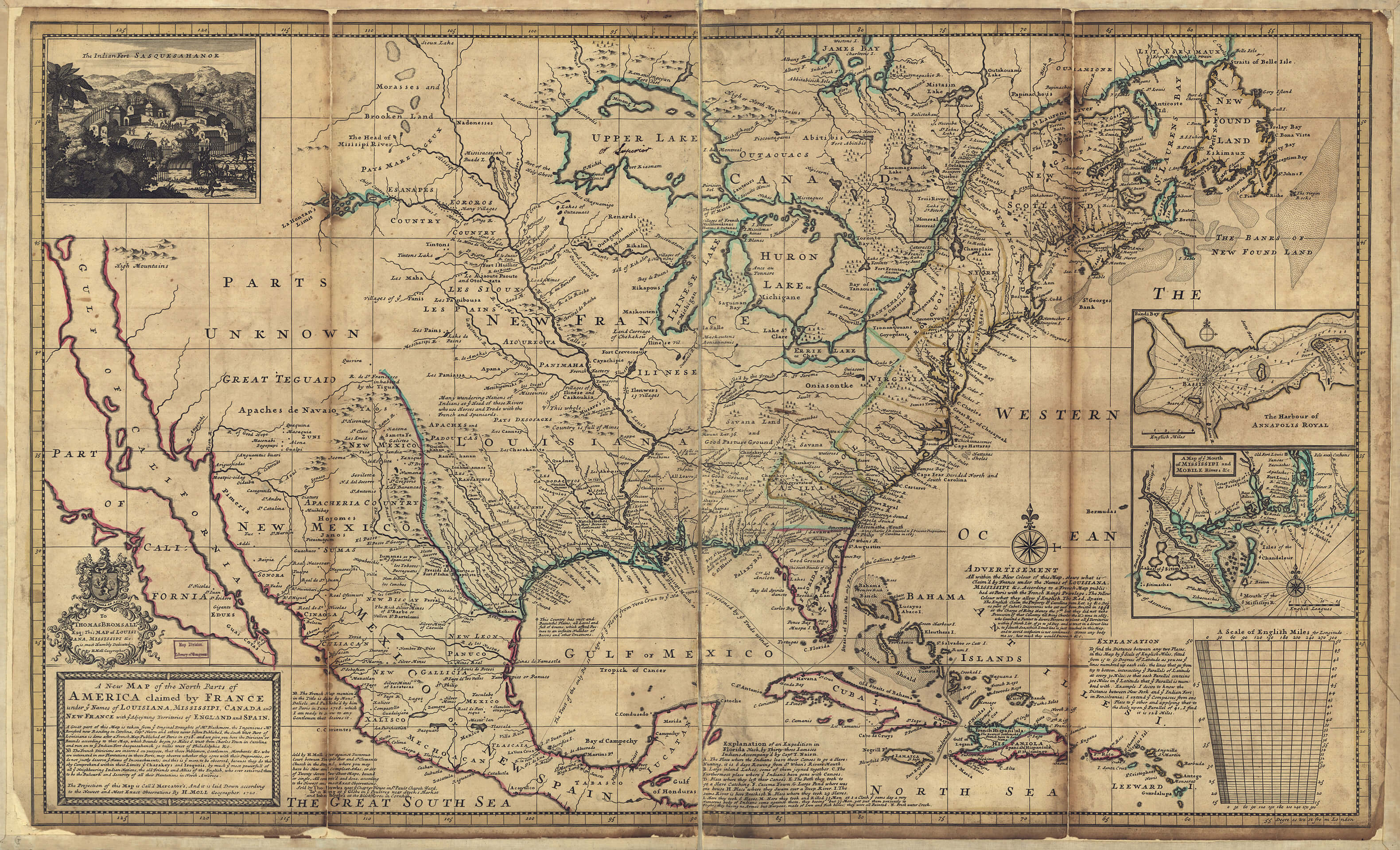
Moll-Map-of-1720-small
Moll’s map of 1720 has “Savannah Old Settlement” at the mouth of the Cumberland, showing that the term Savannah was sometimes applied to the Western as well as to the eastern band
These western Shawnee may possibly be the people mentioned in the Jesuit Relation of 1648, under the name of “Ouchaouanag,” in connection with the Mascoutens, who lived in northern Illinois. In the Relation of 1670 we find the “Chaouanon” mentioned as having visited the Illinois the preceding year, and they are described as living some distance to the south east of the latter. From this period until their removal to the north they are frequently mentioned by the French writers, sometimes under some form of the collective Iroquois name Toagenha, but generally under their Algonquian name Chaouanon. La Harpe, about 1715, called them Tongarois, another form of Toagenha. All these writers concur in the statement that they lived upon a large southern branch of the Ohio, at no great distance east of the Mississippi. This was the Cumberland River of Tennessee and Kentucky, which is called the River of the Shawnee on all the old maps down to about the year 1770.
 
When the French traders first came into the region the Shawnee had their principal village on that river near the present Nashville, Tennessee. They seem also to have ranged northeastward to Kentucky River and southward to the Tennessee. It will thus be seen that they were not isolated from the great body of the Algonquian tribes, as has frequently been represented to have been the case, but simply occupied an interior position, adjoining the kindred Illinois and Miami, with whom they kept up constant communication. As previously mentioned, the early maps plainly distinguish these Shawnee on the Cumberland from the other division of the tribe on Savannah River.

These western Shawnee are mentioned about the year 1672 as being harassed by the Iroquois, and also as allies and neighbors of the Andaste, or Conestoga, who were themselves at war with the Iroquois. As the Andaste were then incorrectly supposed to live on the upper waters of the Ohio River, the Shawnee would naturally be considered their neighbors. The two tribes were probably in alliance against the Iroquois, as we find that when the first body of Shawnee removed from South Carolina to Pennsylvania, about 1678, they settled adjoining the Conestoga, and when another part of the same tribe desired to remove to the Delaware in 1694 permission was granted on condition that they make peace with the Iroquois. Again, in 1684, the Iroquois justified their attacks on the Miami by asserting that the latter had invited the Satanas (Shawnee) into their country to make war upon the Iroquois. This is the first historic mention of the Shawnee evidently the western division in the country north of the Ohio River. As the Cumberland region was out of the usual course of exploration and settlement, but few notices of the western Shawnee are found until 1714, when the French trader Charleville established himself among them near the present Nashville. They were then gradually leaving the country in small bodies in consequence of a war with the Cherokee, their former allies, who were assisted by the Chickasaw. From the statement of Iberville in 1702 8 it seems that this was due to the latter’s efforts to bring them more closely under French influence. It is impossible now to learn the cause of the war between the Shawnee and the Cherokee. It probably did not begin until after 1707, the year of the final expulsion of the Shawnee from South Carolina by the Catawba, as there is no evidence to show that the Cherokee took part in that struggle.

From Shawnee tradition the quarrel with the Chickasaw would seem to be of older date. After the reunion of the Shawnee in the north they secured the alliance of the Delawares, and the two tribes turned against the Cherokee until the latter were compelled to ask peace, when the old friendship was renewed. Soon after the coming of Charleville, in 1714, the Shawnee finally abandoned the Cumberland valley, being pursued to the last moment by the Chickasaw. In a council held at Philadelphia in 1715 with the Shawnee and Delawares, the former, “who live at a great distance,” asked the friendship of the Pennsylvania government. These are evidently the same who about this time were driven from their home on Cumberland river.

To Be Continued Winter 2018
 
Piqua Shawnee Tribe
"Piqua Shawnee"


Friday, September 14, 2018

History Of The Shawnee: Part 2

PART 2:

As published in the Official Newsletter of the Piqua Shawnee (Fall 2018)

By Barbara Lehmann, Piqua Shawnee Tribal Historic Preservation Officer


Barbara’s History Corner:
 
On De l’Isle’s map, also, we find the Savannah River called “R.des Chouanons,” with the “Chaouanons” located upon bothbanks in its middle course. As to Gallatin’s statement that the name of the Savannahs is dropped after Lawson’s mention in 1701, we learn from numerous references, from old records, in Logan’s Upper South Carolina, published after Gallatin’s time, that all through the period of the French and Indian war, 50 years after Lawson wrote, the “Savannahs” were constantly making inroads on the Carolina frontier, even to the vicinity of Charleston. They are described as “northern savages” and friends of the Cherokee, and are undoubtedly the Shawnee. In
1749 Adair, while crossing the middle of Georgia, fell in with a strong party of “the French Shawano,” who were on their way, under Cherokee guidance, to attack the English traders near Augusta. After committing some depredations they escaped to the Cherokee. In another place he speaks of a party of “Shawano Indians,” who, at the instigation of the French, had attacked a frontier settlement of Carolina, but had been taken and imprisoned. Through a reference by Logan it is found that these prisoners are called Savannahs in the records of that period. In 1791 Swan mentions the “Savannas” town among the Creeks, occupied by “Shawanese refugees.” Having shown that the Savannah and the Shawnee are the same tribe, it remains to be seen why and when they removed from South Carolina to the north. The removal was probably owing to dissatisfaction with the English setters, who seem to have favored the Catawba at the expense of the Shawnee. Adair, speaking of the latter tribe, says they had formerly lived on the Savannah River, “till by our foolish measures they were forced to withdraw northward in defense of their, freedom.” In another place he says, “by our own misconduct we twice lost the Shawano Indians, who have since proved very hurtful to our colonies in general.” The first loss referred to is probably the withdrawal of
the Shawnee to the north, and the second is evidently their alliance with the French in consequence of the encroachments of the English in Pennsylvania.
 
Their removal from South Carolina was gradual, beginning about 1677 and continuing at intervals through a period of more than 30 years. The ancient Shawnee villages formerly on the sites of Winchester, Virginia, and Oldtown, near Cumberland, Maryland, were built and occupied probably during this migration. It was due mainly to their losses at the hands of the Catawba, the allies of the English, that they were forced to abandon their country on the Savannah; but after the reunion of the tribe in the north they pursued their old enemies with unrelenting vengeance until the Catawba were almost exterminated. The hatred cherished by the Shawnee toward the English is shown
by their boast in the Revolution that they had killed more of that nation than had any other tribe.
 
The first Shawnee seem to have removed from South Carolina in 1677 or 1678, when, according to Drake, about 70 families established themselves on the Susquehanna adjoining the Conestoga in Lancaster County, Pennsylvania, at the mouth of Pequea creek. Their village was called Pequea, a form of Piqua. The Assiwikales (Hathawekela) were a part of the later migration. This, together with the absence of the Shawnee names Chillicothe and Mequachake east of the Alleghanies, would seem to show that the Carolina portion of the tribe belonged to the first named divisions. The chief of Pequea was Wapatha, or Opessah, who made a treaty with Penn at Philadelphia in 1701, and more than 50 years afterward the Shawnee, then in Ohio, still preserved a copy of this treaty. There is no proof that they had a part in Penn’s first treaty in 1682.
 
In 1694, by invitation of the Delawares and their allies, another large party came from the south probably from Carolina and settled with the Munsee on the Delaware, the main body fixing themselves at the mouth of Lehigh river, near the present Easton, Pennsylvania, while some went as far down as the Schuylkill. This party is said to have numbered about 700, and they were several months on the journey. Permission to settle on the Delaware was granted by the Colonial government on condition of their making peace with the Iroquois, who then received them as “brothers,” while the Delawares acknowledged them as their “second sons,” i. e. grandsons. The Shawnee today refer to the Delawares as their grandfathers. From this it is evident that the Shawnee were never conquered by the Iroquois, and, in fact, we find the western band a few years previously assisting the Miami against the latter. As the Iroquois, however, had conquered the lands of the Conestoga and Delawares, on which the Shawnee settled, the former still claimed the prior right of domain. Another large part of the Shawnee probably left South Carolina about 1707, as appears from a statement made by Evans in that year 5, which shows that they were then hard pressed in the south. He says: “During our abode at Pequehan [Pequea] several of the Shaonois Indians from ye southward came to settle here, and were admitted so to do by Opessah, with the governor’s consent, at the same time an Indian, from a Shaonois town near Carolina came in and gave an account that four hundred and fifty of the flat headed Indians [Catawba] had besieged them, and that in all probability the same was taken.
 
To Be Continued
 
Piqua Shawnee Tribe
"Piqua Shawnee"


Wednesday, October 18, 2017

Piqua Shawnee

Piqua Shawnee

From Bhamwiki
Bhamwiki, now in its tenth year, is an encyclopedic resource for anyone curious about Birmingham, Alabama and the region around it. We aim for accuracy, objectivity, and accessibility as we work steadily to expand our coverage.
Bhamwiki has more than twelve thousand individual entries to explore. Peruse some of the featured articles, or newest entries. Look at what happened on this date in Birmingham's history. Take a chance by clicking on "random page" to the left. Or, if you know what you're looking for, try using the search box, or you can even start at the top and work your way down.


The Piqua Shawnee (officially the Picqua Sept of Ohio Shawnee) is one of nine indigenous tribes recognized by the Alabama Indian Affairs Commission. Evidence for Shawnee settlement in present-day Alabama dates to the late 17th century.

The Shawnee tribe was centered in the area of present day Indiana and Ohio. The Picqua or Peckuwe Sept was one of five tribal divisions named for a legendary evil man who was sent back from death to lead a group of Shawnee to walk in harmony with the great spirit. He appeared to the group in a cloud of smoke billowing from the coals of their fire. "Peckuwe" means "man who rises from the ashes."
The tribe was forced twice to scatter, first by the Iroquis in the 1660s. Some settled in Alabama, where they lived among and were often grouped with other tribes as "Creeks" by traders in the territories. The Alabama Shawnee, unlike many of their tribesmen north of the Tennessee River, did not return to Ohio after peace was made. A new wave arrived in the late 18th and early 19th century, seeking refuge from the continuing fighting between French, English and American interests in King George's War and the French and Indian War.

It was among the Shawnee that an outbreak of smallpox introduced by infected blankets from Fort Pitt during Pontiac's rebellion took its greatest toll. Other tribes which had allied with the French in King George's War had already been exposed to the disease. Smallpox spread with the Shawnee into Creek territory in the South, and then among the Chickasaw and Choctaw and to British colonists as well.

After the Creek Indian War most indigenous people were resettled in the Oklahoma territory, but many were able to avoid resettlement or later returned. The Picqua Sept now represents a small number of interrelated families that preserve Shawnee heritage and live scattered around the south, midwest and Canada. The tribe was officially recognized in Kentucky in 1991 and in Alabama in 2001.

Visit the Official Website of the Piqua Shawnee Tribe
www.piquashawnee.com

Monday, October 16, 2017

Treaty of Fort Wayne (1809)

The Treaty of Fort Wayne (1809)

Tecumseh's War
The two principal adversaries in the conflict, chief Tecumseh and American politician William Henry Harrison, had both been junior participants in the Battle of Fallen Timbers at the close of the Northwest Indian Wars in 1794. Tecumseh was not among the Native American signers of the Treaty of Greenville, which had ended the war, when the Shawnee and other Native Americans ceded much of their historic territory in present-day Ohio to the United States. However, many Indian leaders in the region accepted the Greenville terms, and for the next ten years pan-tribal resistance to American hegemony faded.


The Treaty of Fort Wayne, sometimes called the Ten O'clock Line Treaty or the Twelve Mile Line Treaty, is an 1809 treaty that obtained 3,000,000 acres (approximately 12,000 km²) of American Indian land for the white settlers of Illinois and Indiana. The tribes involved were the Delaware, Eel River, Miami tribe, and Potawatomi in the initial negotiations; later Kickapoo and the Wea, who were the primary inhabitants of the region being sold. The negotiations did not include the Shawnee who were minor inhabitants of the area purchased and had been asked to leave the area previously by Miami War Chief Little Turtle. Territorial Governor William Henry Harrison negotiated the treaty with the tribes. The treaty led to a war with the United States began by Shawnee leader Tecumseh and other dissenting tribesmen in what came to be called "Tecumseh's War".

Tecumseh was outraged by the Treaty of Fort Wayne, believing that American Indian land was owned in common by all tribes, an idea advocated in previous years by the Shawnee leader Blue Jacket and the Mohawk leader Joseph Brant.[30] In response, Tecumseh began to expand on the teachings of his brother, known as The Prophet, who called for the tribes to return to their ancestral ways. He began to associate the teachings with the idea of a pan-tribal alliance. Tecumseh traveled widely, urging warriors to abandon the accommodationist chiefs and to join the resistance at Prophetstown.[30]

Negotiations

The treaty also has two nicknames, the "Ten O'clock Line Treaty of 1809" and the "Twelve Mile Line Treaty". The first nickname comes from tradition that says the Native Americans did not trust the surveyors' equipment, so a spear was thrown down at ten o'clock and the shadow became the treaty line. There are other myths that say it was either a tree or a fence that was used. The Twelve Mile Line was a reference to the Greenville Treaty and the establishment of a new 'line' parallel to it but twelve miles further west.

In 1809 Harrison began to push for a treaty to open more land for settlement. The Miami, Wea, and Kickapoo were "vehemently" opposed to selling any more land around the Wabash River.[1] In order to influence those groups to sell the land, Harrison decided, against the wishes of President James Madison, to first conclude a treaty with the tribes willing to sell and use them to help influence those who held out. In September 1809 he invited the Pottawatomie, Lenape, Eel Rivers, and the Miami to a meeting in Fort Wayne. In the negotiations Harrison promised large subsidies and payments to the tribes if they would cede the lands he was asking for.[2]
 
Only the Miami opposed the treaty. They presented their copy of the Treaty of Greenville and read the section that guaranteed their possession of the lands around the Wabash River. They then explained the history of the region and how they had invited the Wea and other tribes to settle in their territory as friends. The Miami were concerned the Wea leaders were not present, although they were the primary inhabitants of the land being sold. The Miami also wanted any new land sales to be paid for by the acre, and not by the tract. Harrison agreed to make the treaty's acceptance contingent on approval by the Wea and other tribes in the territory being purchased, but he refused to purchase land by the acre. He countered that it was better for the tribes to sell the land in tracts so as to prevent the Americans from only purchasing their best lands by the acre and leaving them only poor land to live on.[2]

After two weeks of negotiating, the Pottawatomie leaders convinced the Miami to accept the treaty as reciprocity to the Pottawatomie who had earlier accepted treaties less advantageous to them at the request of the Miami. Finally the Treaty of Fort Wayne was signed on September 29, 1809, selling United States over 3,000,000 acres (approximately 12,000 km²), chiefly along the Wabash River north of Vincennes.[2] During the winter months, Harrison was able to obtain the acceptance of the Wea by offering them a large subsidy and the help of Miami Chief Pacanne who helped to influence the Wea leaders. The Kickapoo were closely allied with the Shawnee at Prophetstown and Harrison feared they would be difficult to sway. He offered the Wea an increased subsidy if the Kickapoo would also accept the treaty, causing the Wea to pressure the Kickapoo leaders to accept. By the spring of 1810 Harrison had completed negotiations and the treaty was finalized.[3]

Visit the Official Website of Piqua Shawnee

Wednesday, October 11, 2017

Shawnee Ceremonial Dance: Fall Bread Dance


Shawnee Ceremonial Dance: Fall Bread Dance


As with other Indian Nations, Shawnee ritual was expressed most publicly in their dances.  The Shawnee ritual year opened with the Spring Bread Dance and closed with the Fall Bread Dance.  Some Shawnee groups had a Green Corn Dance, but it was not the beginning of the ritual year as in other northeastern or southeastern woodland groups. It was rather related to the first ripening of the corn in early summer.  In keeping with its basic subsistence pattern of hunting and gathering, the Shawnee moons were related to this aspect of their annual cycle rather than to planting, weeding and harvesting of the maize crop.

Sources:

Erminie-Wheeler Voegelin with a cover letter letter to Frank Speck, signed by Carl and Erminie Voegelin.  572.97 Sp3 in the Frank G. Speck Papers, APS III. Northeast, E.  Miscellaneous Tribes, 2. Shawnee, c. Shawnee Dances (Freeman Guide, 3649).  CFV undoubtedly did the eliciting of the terms and EWV the ethnological descriptions.  The cover letter is dated July 15, 1934 at 332 Kickapoo St., Shawnee, Oklahoma.

Invaluable as well are dances listed by Lewis Henry Morgon during his fieldwork in Kansas among the Shawnee in 1859-60.  His source was Blue Jacket. The Shawnee Prophet, in Shawnee Traditions by Trowbridge (1824) lists some dances as well. In the discussion of Shawnee ritual, James H. Howard's contributions to Shawnee Ceremonies, in Shawnee!, will be fully utilized.

Fall Bread Dance:

Tak'wanekaawe

Prophet: Tuhkoakaawaa "is a dance performed by women. It is danced for amusement only.  This peculiarity and the custom of the women to  join the man in singing are its only characteristics. The dancers form a line, fronting the man who sings, and they join him in singing a kind of prelude, which continues some minutes, when they commence, the man singing alone, and dance around in a circular manner."

Erminie-Wheeler Voegelin "Season for all dances closes with this, a night dance of amusement following the same evening of the Bread Dance and being the last such until the next spring. A night dance follows immediately after dark on the same day that the Bread Dance is danced; this closes the season for night dances of amusement.  No dances given after that until the Spring Bread Dance."

Learn more and view the full collection of Frank Gouldsmith Speck Papers and Background:


Piqua Shawnee

Tuesday, October 3, 2017

Shawnee! The Ceremonialism of a Native American Tribe and its Cultural Background (Book)

Shawnee! The Ceremonialism of a Native American Tribe and its Cultural Background

Monday, October 2, 2017

Tecumseh: Vision of Glory (Book) By Glenn Tucker


Tecumseh: Vision of Glory

Pickle Partners Publishing, Nov 6, 2015 - Biography & Autobiography - 407 pages

Author: Glenn Tucker
In the years just preceding the War of 1812 one man, an Indian, dominated the American frontier—Tecumseh. He emerges here as a vivid, splendid character, a man of unusual talents and noble aims, whereas in much previous history and biography he has been depicted as a baffling, sinister, often bloody figure—a man of inscrutable motives whose scheming for a time actually threatened to delay the settlement of the Northwest.

Tecumseh’s great oratorical powers, his statesmanship, his military acumen, his personal magnetism won him the passionate loyalty of his Indians and the admiration of even his white enemies. In nobility of character, in leadership and in devotion to a lost cause he suggests points of comparison with Robert E. Lee.

The need for this book is indicated by the fact that until its publication the standard biography has continued to be Benjamin Drake’s book first published in 1841 and ranks as a collectors’ item.

Tecumseh’s great vision was a confederation of all the Indian tribes to check the encroachment of the whites on the Indian lands. His journeys took him from the Mohawk River in the east to the Arkansas in the west, from Lake Superior to the Gulf of Mexico.

Mr. Tucker offers proof that the British in Canada did not push Tecumseh on war with the United States—as historians have claimed—but on the contrary Tecumseh urged the British to declare war.

The high point of Tecumseh’s point probably came when with Major General Brook he captured Detroit and made a sizeable American army to surrender. Only a few months later his forces, outnumbered and almost unsupported by their brave and futile stand on the Thames River. Tecumseh was killed, and his dream of a red empire broken. So ended the mighty vision and the greatest of the great chiefs.
Piqua Shawnee

Monday, September 25, 2017

Pioneer Days, Simon Kenton Festival, Piqua Shawnee


Students learn, have fun at Pioneer Days,  Simon Kenton Festival  

    The Ledger Independent by


    MAYSVILLE -- Students from Mason County Intermediate School received history lessons Friday about the early days of Kentucky.
    The students traveled to Old Washington for the annual Pioneer Days where they learned about crops grown, what homes looked like, played old-fashioned games and had a chance to pet horses and oxen.

    "This is a great learning experience for the students," Kim Galloway, special education teacher said. "They got to see a lot of things they would never get to experience."

    Abby Collen-Nickell, Madison Hardin and Kionna Alexander said they had a lot of fun singing the old songs as Mary McGlone played the dulcimer.

    High school volunteers Sarah Crason, Constance Craig and Grace Huber, dressed in periodic clothing, played old-fashioned games such as duck-duck-goose and hopscotch with the students while other students took a moment to eat lunch on the old courthouse lawn.
    Other students took turns petting Gerry Barker's oxen while others learned how to throw hatchets and use a bow and arrow from Josh Kriger.

    Students also learned about the goods that were used in the pioneer days.

    Piqua Shawnee Chief Gary Hunt, along with other Native American volunteers, took time to speak with the students about the roles Indians played back in those days.

    This is Hunt's 12th year in the re-enactment as Simon Kenton was adopted by a Shawnee tribe.
    "The organizers wanted to bring my people and the Kentons back together for a type of reunion," he said. "I enjoy my time here. It is a chance to portray history without dealing with the politics."
    Hunt said he enjoys seeing the children faces as they get enjoyment seeing Native Americans.
    "We are bringing real history to them," he said. "I enjoy being in the land of my ancestors."


    http://www.maysville-online.com/news/local/students-learn-have-fun-at-pioneer-days/article_41bf7d86-51fa-5c08-a15e-439c15eacc8d.html

    Friday, September 15, 2017

    The Shawanese prophet and Tecumseh / Huyot. Wood Engraving


    Library of Congress - Wood engravings--1810-1890.

    Tecumseh,--Shawnee Chief,--1768-1813

    Tenskwatawa,--Shawnee Prophet

     Created / Published [between 1814 and 1890]

     The Shawanese prophet and Tecumseh / Huyot.

    Print shows Tenskwatawa, the Shawnee Prophet, and Tecumseh, 
    with other Natives and tipis in the background.


    Library of Congress Prints and Photographs Division Washington, D.C. 20540 USA http://hdl.loc.gov/loc.pnp/pp.print

    Digital Id
    cph 3a20703 //hdl.loc.gov/loc.pnp/cph.3a20703

    Library of Congress Control Number
    2012645311


    Library of Congress Link:


    Visit the Official Website of the Piqua Shawnee: